Thursday, December 13, 2012

Take Me To The Sanatorium...

One of the more interesting tid bits about or neighborhood is that the building across the street from our house played a role Alfred Hitchcock's Vertigo.  The movie was filmed in San Francisco and many local sites were used as backdrops to Hitchcock's story.


In the movie, after visiting Madeline's grave, Jimmy Stewart's character, Scottie, suffers a nightmare causing him to have a nervous breakdown requiring treatment at a sanatorium. He is taken to the St. Joseph's Hospital on Buena Vista East facing Buena Vista Park.  The below images show a screen shot from Vertigo (top) and the same view from just a few years ago (bottom).


The hospital is now the Park Hill Condominium and the back end of the building on Park Hill faces our house.

Monday, December 3, 2012

Blue Balls with History

While we are working diligently on the house and planing - we could not possibly overlook the landscaping and art - could we?

We found these really neat blue steel buoys at 14 Feet in Healdsburg and thought they would make a great addition to the front yard, which will be terraced with a series of concrete retaining walls.  


As it turns out these buoys have some really interesting history - they were used during World War II to net the San Francisco Bay against Japanese Submarines.  

San Francisco was a major port and naval base that was vital to the war in the Pacific.  It was well protected by mines, guns, and numerous coastal batteries mounting 40mm anti-aircraft guns all the way up to 16 inch naval guns at Fort Cronkite and Fort Funston. In addition to these defenses, on September 15, 1941, the War Department authorized a submarine net to be positioned across the Golden Gate to prevent access to the bay by Japanese submarines.  These buoys, along with about another 100 buoys, held the net in place during the War.  The net was made and serviced at the Tiburon Naval Net Depot and at Alcatraz prison.  Navy ships would open and close the net for friendly vessels.  The below picture shows the buoys with the net just before the net was installed in the bay.


After the war the nets were recovered and returned to Tiburon for storage in case of future need. Eventually, they were salvaged, the nets went to scrap dealers, the massive concrete anchors became bulkheads for shoreline protection at the depot and what is now Paradise Park, and many of the huge buoys became beehives around California. The gantries were removed, leaving only the tracks on which they ran and a concrete trestle down the center of the base.

As can be seen by the below map, the submarine net spanned from Fort Mason on the San Francisco side to Sausalito on the Marin side.


For additional information on the harbor defenses during World War II see http://www.nps.gov/goga/historyculture/world-war-ii-harbor-defenses.htm 


Tuesday, November 20, 2012

Final Renderings

Now that the Planing Department has granted us approval of our overall design, we can move forward with finalizing the details relating to cost and construction planning.

Below are the final renderings of the house.  The first image is a view of the house from Buena Vista Park on Park Hill Ave. towards Corona Heights.  The second image is a view of the house looking up from Roosevelt Way.  The third image is a view of the house from the intersection of Roosevelt Way and 15th Street at dusk.

Thanks to Mark Dessert of Powder Haus Studios for the fantastic renderings that bring the design from gb architecture + design to life.


Approved!

We have now received notice from the San Francisco Planning Department that the overall site plan and our variance have been approved!  The variance has been now recoded with our deed and we are moving forward with finalizing the building permits.

This is a substantial milestone in the process and now that it is complete the next steps in the process will move swiftly along.


Wednesday, August 22, 2012

A Street Runs Through It


While preparing our submission for Planning Department review, we had to have a historical evaluation of the property prepared by a third party.  While most of the history of the property was rather boring and non-eventful, a small bit of history that discussed the development of the neighborhood over the past century caught our eye.  This history also shed some light on how such an odd shaped lot came into existence.

As noted in a previous blog post, prior to 1900, the neighborhood was dominated by the Gray Brothers Quarry, which produced most of the bricks that lined the San Francisco cable car lines throughout the city.  During the time of the quarry, streets had been cut out of the rock for transport vehicle access and from the general quarrying done to the area. This made the location prime real estate for people who began to build their homes on the streets cut into the hill. 


The first Sanborn map illustrating the immediate area surrounding the property was published in 1899. At this time the block did not include the current section of Roosevelt Way, which was not a thoroughfare until after 1920.  The reproduced Sanborn map below shows the current boundaries of property (identified with the arrow) as it fit in the existing block in 1899. The area was sparsely developed with single-family homes and hospital facing Buena Vista Park.  


1899 Sanborn Map showing approximate location of the property

The 1913 Sanborn map shows the gradual development of the surrounding blocks with several more single family and multiple family residences. Prior to construction of the current house that sits on the property, the approximate location of the parcel contained two modest one-story single-family homes (see the arrow pointing to the triangle outline of our property). In addition, several streets in the neighborhood had been renamed; South Broderick was changed to Buena Vista Terrace and Tilden was changed to 15th Street.


1913 Sanborn Map

In 1926, the present St. Joseph’s Hospital building, replacing the 1889 hospital building, was constructed to a Bakewell and Brown design. Around the same time, Roosevelt Way was cut through joining 14th through 17th streets. This and other street reconfigurations made Buena Vista Park, which was designated in 1867, more accessible from Eureka Valley and the south. The southern end of the block was cut through in order for Roosevelt Way to continue east where it terminated at Alpine Terrace. 


The reproduced 1950 Sanborn map shows the transformation of the neighborhood after Roosevelt Way cut through the southern end of the block containing our property. At this point, the block was completely developed with single and multiple-family residences. The map also shows the property with a one-story-over-basement single-family home as it was originally constructed.


1950 Sanborn Map


Saturday, August 18, 2012

Siding With History


With the design of the house well underway, the next step was to pick the siding for the house.  We were fortunate enough to work with a wood broker and secure 100+ year old-growth reclaimed redwood that was used under the galvanized steel sheathing on Hanger One at Moffett Field that will be used for siding for the house.  Hanger One is currently undergoing renovation and will be reclad.

Just a bit of history, Hanger One at Moffett Field was completed in 1931 and is built on a network of steel girders sheathed in galvanized steel. The building’s footprint covers 8 acres without any internal columns, making it one of the world's largest freestanding structures. The structure was designed by Prague-born airship and structural engineer Dr. Karl Arnstein, who was also the chief designer of the U.S. Navy airships the USS Akron and the USS Macon.  Hanger One was originally built to house the USS Macon, shown in the picture below.

The USS Macon was built by the U.S. Navy for air reconnaissance. It also served as a “flying aircraft carrier” with the capacity to carry five F9C Sparrowhawk biplanes. The planes were stored in bays inside the hull.  The zeppelin was kept aloft by 12 helium-filled gas “balloons” or cells within the main hull. The airship was powered by eight German-made Maybach 12-cylninder 560 hp gasoline powered engines with propellers that could be rotated downwards or backwards to provide thrust vectoring.


The pictures below show the old-growth redwood that was reclaimed form Hanger One that we will be using as siding for the house.


Our wood as it is being loaded on the trucks for delivery to our storage facility.


Friday, March 23, 2012

Rendering Get Refined

We have now begun to incorporate the landscaping into the design of the house, and have revised the renderings to include more of the site.  As you can see from the below images, the triangular lot of land at the intersection of Park Hill and Roosevelt will be terraced using a series of retaining walls, likely concrete, and the leveled land will be planted with a series of native trees and plants with decomposed granite covering the soil.  The entrance to the studio will also be accessed through this area.


Thursday, March 15, 2012

PD-Day

Well, we are not invading Normandy, but today is our first visit to the SF Planning Department. Let's hope we are as equally successful.

Wednesday, March 14, 2012

Empire Star Destroyer?

No, in fact that is NOT an Empire Star Destroyer from Star Wars - it is our first physical model of the house!  The triangular shape of the lot and the sloping terrain results in the dramatic base of the model.

And Then There Was Fire...

As we slowly move on in the house design, one of more important focal points of the house is the fireplace.  Below is our first rough design of the fireplace that will be situation along the south glass wall between the living room and the dining room.  The fireplace will be exposed on three sides and will include a wood storage comparment.

Wednesday, March 7, 2012

Show Me The Renderings!

Now that we have the plans completed for the house, the next step was to have renderings prepared.  Below are the first drafts of the renderings of the house from three different angles prepared by Mark Dessert of PowderHaus.  

Below is the view of the west and south facades of the house looking northeast from Park Hill.


Below is the south facade from the intersection of Park Hill and Roosevelt Way.


Below is the view of the south and east facades of the house from Roosevelt Way.


Monday, March 5, 2012

Survey Says...

....A triangular lot.  One of the more difficult things with dealing with this site is understanding the elevation changes between the Park Hill side of the lot and the Roosevelt Way side of the lot.  In order to get an accurate grasp of the site we had a survey company prepare a land survey of the site that includes all the measurements of the site, including the existing building and neighbor's building, as well all the elevation changes.  Below is the land survey for our site.

Next up...models and renderings.

Tuesday, January 31, 2012

Now That's a Walk-In Closet

After many arguments between client and architect about the location of each and every element - we have finally arrived at floor plans that we are both really happy with. So, without further delay, below are the floor plans for both the main house as well as the studio unit.


Based on the above plans, the current layout of the house will be significantly reconfigured for the new house.  The bottom unit will be decreased to a single floor and will be turned into a studio unit and the main house will be configured into a four bedroom, three bath house with two garages.


The bottom left plan shows the layout for the studio unit.  It will include a small kitchenette, full bathroom and sitting area.  The bottom left plan shows the first floor of the house and it includes three bedrooms, two bathrooms, and den.  This floor also includes a garage that is accessible form Park Hill Avenue.  The second garage is accessible form Roosevelt Way and is one level below the studio unit (see the cross-section below).

The top right plan shows the main common level of the house which includes the living room, dining room, family room, kitchen, and bathroom.  This level will also include the main entrance to the house that will be accessible by an outside staircase from Park Hill Avenue (see elevations from a prior post).

The top left plan shows the master bedroom level, which also includes the master bathroom, walk-in closet, and roof deck.  Yes, now that's a walk-in closet.


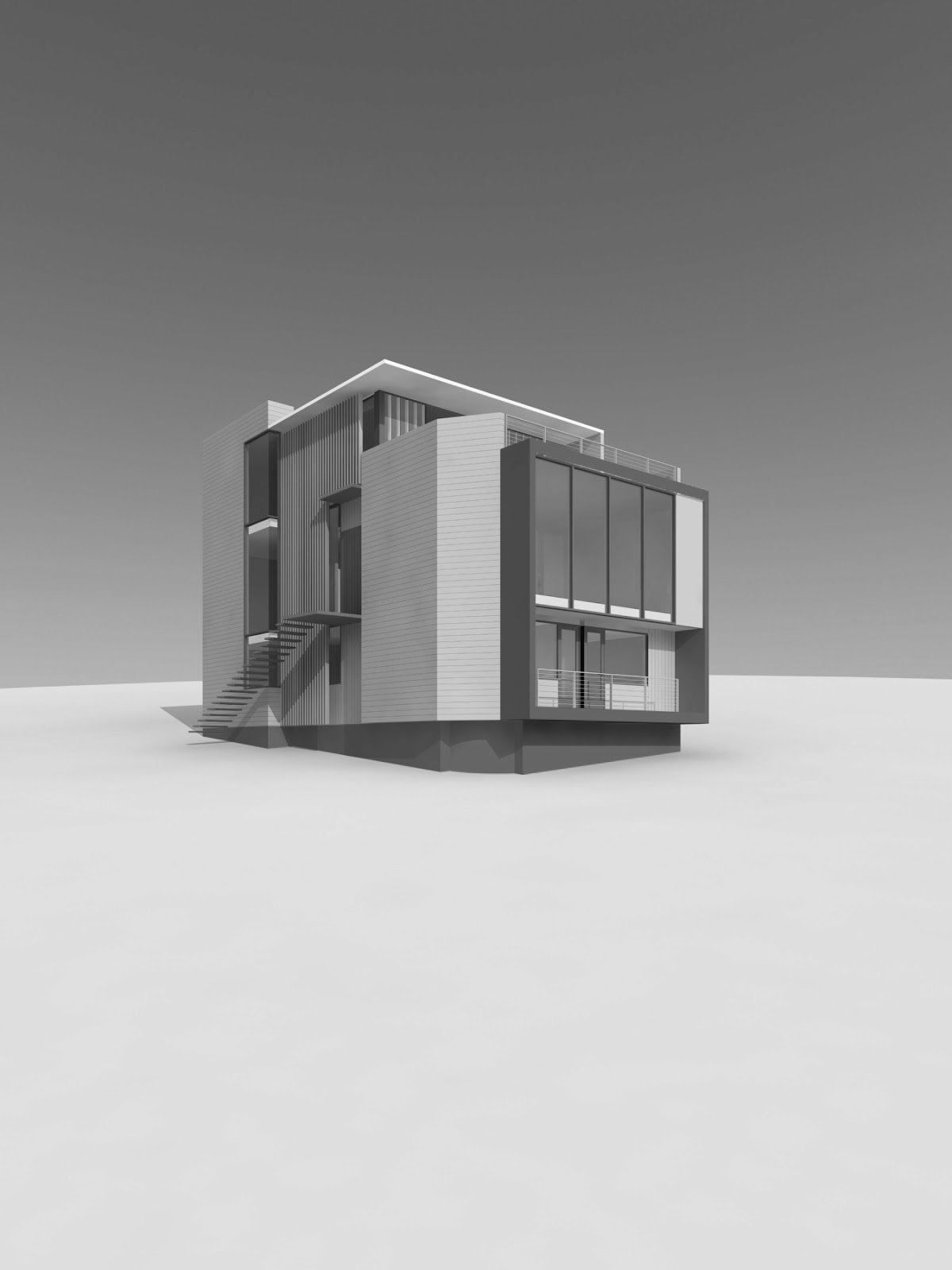
In order to help understand the configuration of the house, below is also a cross section showing the different floors and how they align with the sloping topography of the site.

Monday, January 23, 2012

Return From Hiatus

Over the past few months we have been working on refining the design and we now have some elevations that we are truly proud of and excited to see turn into reality over the next few years.

Below are three elevations of the house - the West elevation shows the house from Park Hill Drive, the South elevation shows the house on the approach form Roosevelt Way and the East elevation shows the house from down the hill on Roosevelt Way.


After a brief hiatus from the blog for the holidays - we are now back and running on all cylinders.  So, stay tuned over the next three months to see in situ renderings of the house, floor plans and further details on the exterior materials.